Pinal County Planning Commission grants approval for 389-acre mixed-use project despite concerns over building heights and traffic impacts.
Key Points
- Project Scale: 389-acre mixed-use development on Arizona State Trust Land with up to 2,338 residential units and 25 acres of commercial space
- Location: East of Hunt Highway and south of Gantzel and Judd Roads, directly north of existing Copper Basin neighborhood
- Three Development Areas: Area A (1,152 single-family homes), Area B (409 mixed residential units), Area C (777 units plus commercial along Hunt Highway)
- Phased Auction: Phase 1 (Areas A & B) scheduled for Q1 2026; Phase 2 (Area C) timing uncertain due to water service issues
- Height Controversy: Area C permits four-story buildings up to 52 feet, drawing concern from commissioners about unprecedented height in San Tan Valley
- Traffic Stipulations: Commissioners modified requirements for Hunt Highway improvements and Tourmaline Drive closures after extensive debate
- Housing Diversity: Development includes single-family homes on lots as small as 4,000 square feet, townhomes, villas, and potential apartments
- Next Step: Project advances to Pinal County Board of Supervisors for final approval
Development Overview
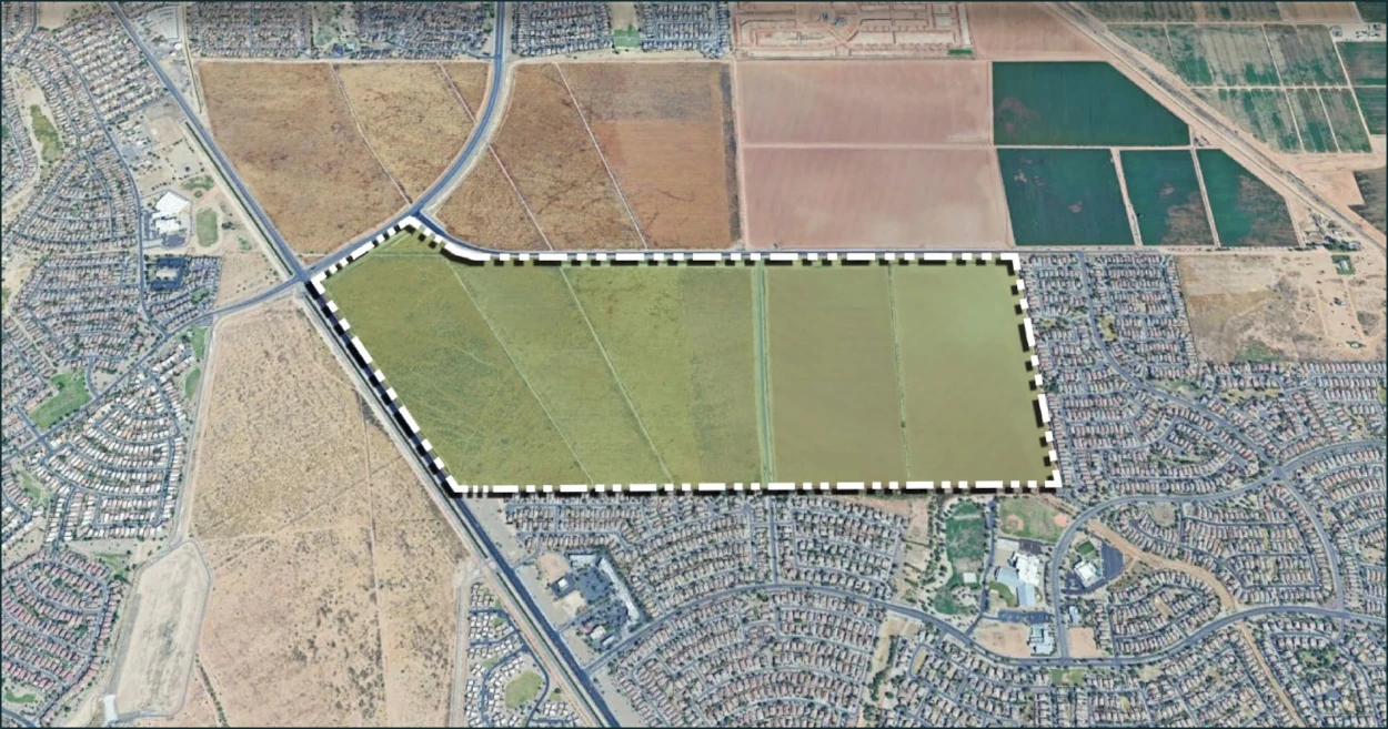
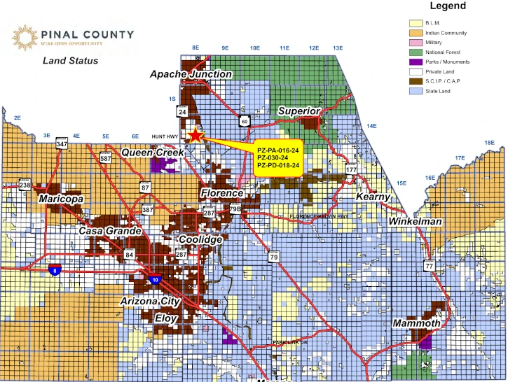
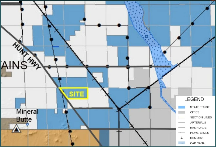
The Pinal County Planning and Zoning Commission unanimously approved three cases on July 7, 2025, for the North Copper Basin development, a 389-acre mixed-use project on Arizona State Land. The development sits east of Hunt Highway and south of Gantzel and Judd Roads, directly north of the existing Copper Basin neighborhood.
North Copper Basin development planned north east of Copper Basin Development.
Alex Stedman of RVi Planning + Landscape Architecture, representing the Arizona State Land Department, presented the proposal for the project. The site requires a comprehensive plan amendment, rezoning from General Rural to multiple districts, and a Planned Area Development overlay to accommodate flexible development standards.
The site consists of relatively flat, previously agricultural land with minor improvements such as concrete irrigation ditches and dirt roads.
Surrounding Area Context
The development borders established communities on multiple sides. To the south and east lies the existing Copper Basin community, developed around 2005 with single-family homes on lots ranging from 45 feet by 110 feet to 60 feet by 115 feet.
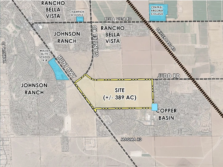
West of Hunt Highway sits the Johnson Ranch community, featuring similar residential development with minimum lot dimensions as small as 45 feet by 100 feet.
To the north, approximately 480 acres of undeveloped General Rural zoned land extends beyond Judd Road, with about 320 acres owned by the Arizona State Land Department.
Three Development Areas with Distinct Purposes
The development divides into three distinct areas, each with different density levels and land uses designed to create a transition from existing neighborhoods to higher-intensity commercial development.
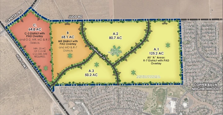
Table: Land Use Areas, Density Caps, and Dwelling Unit Limits
| LAND USE AREA | AREA (AC) | MAX. OVERALL DENSITY CAP OF THE LAND USE AREA | OVERALL DWELLING UNIT CAP OF THE LAND USE AREA |
|---|---|---|---|
| A | 256.1 | 4.5 | 1,152 |
| B | 68.1 | 6 | 409 |
| C (2) | 64.8 | 12 | 777 |
| TOTAL | 389.0 (3) | 6 | 2,338 |
Area A: Single-Family Foundation
Area A encompasses 256.1 acres on the eastern portion of the site, designated for single-family residential development only. The area carries R-7 Single Residence zoning with a maximum density of 4.5 dwelling units per acre, allowing up to 1,152 homes.
Development standards permit lots as small as 40 feet wide and 4,000 square feet, but the plan limits these smallest lots to no more than 30% of total units and 25% of Area A’s land. The development must include at least three substantially different lot sizes, defined as having minimum differences of five feet in width or 500 square feet in area.
Stedman positioned single-family homes in Area A specifically “to give those protections and those transitions to Copper Basin to our west and to our east.” The area includes open space buffers along the Copper Basin border to the south, with a sewer easement and sewer line along the eastern edge creating additional separation between existing and proposed homes.
Area B: Medium-Density Transition
Area B covers 68.1 acres in the center of the development, serving as a transitional zone between single-family areas and higher-intensity commercial uses. The area carries Multiple Residence (MR) base zoning but allows Mixed Dwelling and Single Residence districts under the PAD overlay.
The density cap reaches 6 dwelling units per acre, permitting up to 409 total units. Allowable housing types include single-family homes, townhomes, villas, and duplexes. Multiple Residence uses in Area B face restrictions to detached multi-family only, with building heights limited to 30 feet specifically for MR uses in this area.
Stedman explained the intentional placement: “This would allow some flexibility of residential uses in here. This would be single family uses in combination with mixed dwelling, kind of higher density, not apartments.”
Area C: Commercial and High-Density Hub
Area C occupies 64.8 acres along Hunt Highway, designated for the most intensive development. The area carries C-3 General Commercial base zoning with additional districts including General Office, Multiple Residence, Mixed Dwelling, and Single Residence under the PAD overlay.
The development requires a minimum of 25 acres for commercial or office uses, with the remaining 39.8 acres available for residential development at up to 12 dwelling units per acre. This could yield up to 777 residential units alongside commercial and office space.
Area C permits the tallest buildings in the development, with Multiple Residence structures reaching up to 52 feet or four stories, which generated significant discussion among commissioners.
State Trust Land vs. Private Property
Arizona State Trust Land operates under fundamentally different rules than private property, a distinction Stedman emphasized during his presentation. The land was granted to Arizona by the federal government in preparation for statehood, with revenues supporting 13 essential public service beneficiaries.
“State Trust Land is not public land, it’s more akin to private property in the way that it’s handled,” Stedman explained. “The way that state land is disposed of is through public auction… to the highest bidder.”
Approximately 8 million of Arizona’s remaining 9.2 million acres of State Trust Land generate revenue primarily for K-12 public schools, with additional funding for universities, the School for the Blind and Deaf, and other beneficiaries.
State trust lands cannot be sold for less than fair market value as determined by appraisal, and land sales or leases exceeding ten years require public auction. Unlike public lands such as state parks or U.S. Forest Service land, state trust lands are held in trust specifically to generate revenue for their beneficiaries.
Public Auction Process and Key Players
The Arizona State Land Department will auction the property in phases following the entitlement process. DR Horton has emerged as the likely purchaser for the residential portions, though they do not currently own the property.
As Planning Manager Harvey Krauss explained to Commissioner Mooney’s question about what happens if the sale doesn’t proceed: “The zoning and the land use goes with the ownership. So the state is the applicant, so the state is seeking the zoning application. Not D.R. Horton. D.R. Horton may be one prospective buyer. So there could be other buyers.”
The arrangement allows DR Horton to advance the planning and entitlement work for the state. If they win the auction, they receive reimbursement for these costs. If another bidder wins, that party must pay for the entitlement work.
Carolyn Oberholtzer, outside land use counsel for the Arizona State Land Department, attended the meeting to clarify legal aspects of the state land disposition process and answer questions about right-of-way dedications and timing requirements.
Auction Phasing and Water Service Challenges
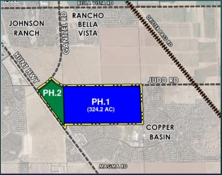
The development will proceed in two distinct phases tied directly to water service availability. Phase 1 encompasses 324 acres covering Areas A and B, scheduled for auction in quarter one of 2026. These areas fall within EPCOR’s existing service area (a private water utility), enabling immediate development upon purchase.
Phase 2 includes the 64.8-acre Area C, which is not within the EPCOR service area. The auction timing for Area C remains undetermined because the water provider hasn’t been established. Stedman acknowledged: “We haven’t even started those conversations yet” with EPCOR regarding Area C service.
Commissioner Mooney questioned the wisdom of considering Area C without water service: “You’re looking at a piece of land that has no water, so I’m just wondering why that’s here today.”
Stedman explained the state’s decision to bifurcate the auction process: “The areas A and B appeal to the DR Hortons of the world and maybe other bidders and builders out there. That’s where the interest is in the near term, so the state has made a decision to bifurcate that property and that auction process.”
Commissioner Daren Schnepf, drawing from his water utility background, noted: “I think they’re waiting probably ’cause there’s no water entitlements on it, so they probably have to get a well served and 100 year water supply for that property. So that theoretically could sit there for a while.”
The uncertainty around Area C exists because it is not within the EPCOR service area, creating a process that needs to be resolved before development can proceed.
Commercial Development Plans
If auctioned and water service is secured, Area C’s commercial component aims to create a walkable mixed-use environment along Hunt Highway. The 25-acre minimum commercial requirement represents nearly 40% of Area C’s total area, ensuring substantial non-residential development.
The commercial zoning permits all uses allowed in Pinal County’s C-3 General Commercial District, providing flexibility for retail, restaurants, and other community services. The plan envisions internal connectivity where “our residents can shop and maybe even work within this larger community, this 389 acre property, as it develops,” according to Stedman.
The commercial area’s location adjacent to Hunt Highway, Gantzel Road, and Judd Road—all planned as Principal Arterials—provides optimal access for higher-intensity commercial uses while maintaining separation from existing residential neighborhoods.
Strategic Density Transition
The development employs a deliberate transition strategy moving from east to west across the site. Area A’s single-family homes at 4.5 dwelling units per acre provide the gentlest transition from existing Copper Basin neighborhoods. Area B’s 6 dwelling units per acre allows medium-density residential uses, while Area C’s 12 dwelling units per acre accommodates the highest intensity development.
“We’re trying to transition this density,” Stedman explained. “C allows for some higher intensity uses. It’s right adjacent to Hunt Highway, so it’s got great access. It’s got great potential for those higher intensity uses. It accommodates the traffic a little bit better.”
This transition places the most intensive development—including potentially four-story buildings and commercial uses—along major arterials while protecting existing neighborhoods with compatible single-family development and substantial open space buffers.
Housing Product Types and Market Diversity
The development will offer diverse housing options across its three areas. Area A (Phase 1) focuses exclusively on detached single-family homes with varying lot sizes to provide options for different income levels and family sizes.
Area B (Phase 1) introduces attached housing types including townhomes, villas, and duplexes alongside continued single-family options. These products typically develop at 10 dwelling units per acre, but the 6 dwelling unit per acre cap ensures a mix of housing types rather than exclusively higher-density development.
Area C (Phase 2) permits residential options including single-family homes and potentially multifamily structures up to four stories, depending on market demand and future site plans. Stedman noted that apartments typically develop at 20 to 25 dwelling units per acre, but the 12 dwelling unit per acre cap prevents Area C from becoming exclusively high-density development.
When Commissioner Schnepf asked whether Area B’s townhomes and villas would be for rent or sale, Stedman responded: “We anticipate it could be both. The way that our proposal is drafted, they could be detached, multifamily, but they also could be for sale, townhomes and villas.”
Building Height Controversy
The four-story building proposal for Area C generated significant discussion among commissioners. The 52-foot maximum height represents a dramatic departure from the area’s current two-story development pattern, particularly since these buildings would be located along Hunt Highway.
Commissioner Scott pressed Stedman on the height proposal: “It’s just kind of hard to vote on something that’s gonna be a what if. You know, 52 feet, that’s pretty high, isn’t it?”
“That’s about a four-story building, yes,” Stedman confirmed.
“How many four-story buildings are within three miles of there?” Scott continued.
“None,” Scott answered.
“None yet,” Stedman added.
Commissioner Mooney reinforced the concern: “I don’t even think we have three-story buildings in San Tan Valley yet. So four stories, not a big fan.”
Mooney also raised questions about whether five-foot side and rear setbacks were consistent with recent commission discussions.
The commissioners ultimately approved the height allowance, but the discussion highlighted ongoing tensions between development intensity and community character preservation in San Tan Valley.
Professional Housing Market Concerns
Vice-Chairman Robert Klob raised broader concerns about housing diversity and the need to accommodate higher-income professionals in Pinal County developments. His comments reflected worry about an overfocus on smaller, more affordable housing at the expense of move-up buyers.
“As so many of these developments come into Pinal County, we’re losing the diversity because there’s so much focus right now politically and as a country, on affordable housing and creating small, more affordable lots. And I support that 100%, but I don’t think it needs to be the only thing that we do,” Klob stated.
“And there needs to be housing in all of these communities for that next level move up, for the professionals that are coming in here that are maybe a little higher income individuals that wanna live out in this area. I think we’re losing a lot of that housing stock because the developers are so laser focused on small lot builds, that they’re losing the focus on larger lots.”
Klob continued: “We need workforce housing, but we also need housing for the business owners and the doctors and the lawyers and so on and so forth, that these communities need and will need in the future.”
His comments underscored ongoing debates about balanced development that serves multiple income levels and professional categories in growing suburban areas.
Traffic and Infrastructure Stipulations
The commission extensively debated stipulations affecting traffic flow and infrastructure timing, particularly concerning Tourmaline Drive realignment and Hunt Highway improvements. These discussions revealed complex relationships between development phasing, traffic impacts, and infrastructure financing.
Tourmaline Drive Modifications
The development proposes realigning Tourmaline Drive, which currently runs straight north-south through the site. The new design would create a curvilinear alignment that, according to the applicant’s proposal, “continues the curvilinear street pattern throughout Copper Basin” while reducing cut-through traffic and vehicle speeds.
Original stipulation language prohibited any closure of Tourmaline Drive, requiring maintaining physical access “at all times (i.e. Road cannot be closed at any time).” Stedman requested modifying this requirement to allow temporary closures for infrastructure tie-ins: “From time to time, we’re gonna need some flexibility to, for infrastructure tie-in, whether it’s water, sewer, or street improvements as the community’s developing.”
The applicant proposed allowing temporary closures with sufficient advance notice to the county, estimating closures would last “days, maybe a week” rather than extended periods. County staff confirmed they would require maintaining two separate access points for fire safety at all times.
Commissioner Mooney expressed concern about road closure impacts, noting her experience with similar construction disruptions in San Tan Valley and emphasizing the need to coordinate closures for the shortest possible duration.
The commission ultimately approved the modified language allowing temporary closures with advance notice and coordination with county engineering.
Hunt Highway Dedication Timing
Stipulation 5 originally required Hunt Highway right-of-way dedication concurrent with any final plat approval. The applicant requested modifying this requirement to tie Hunt Highway dedications specifically to Area C development, since Areas A and B would be auctioned first while Area C faces water service uncertainty.
Vice-Chairman Klob expressed concern about this approach: “My concern is, allowing a stipulation like this, that says, we already know that there’s some entitlement challenges with Area C. Logistically, it’ll probably happen. I get it. But on the flip side, if it doesn’t, and that never develops, so now we have this, you know, what do we have, 2,000 homes or whatever it is, that now don’t get the benefit of a Hunt Highway development because C never got developed.”
Klob worried about creating a “zombie site” where Area C remains undeveloped for decades while thousands of residents lack improved highway access: “We have sites that have sat, potentially great sites, sat for 20 years and not developed. And this is my concern with this area… how do we get what the bulk of this community is going to need.”
Attorney Carolyn Oberholtzer explained the legal complexities of state trust land and right-of-way dedications, noting that state statute allows tying off-site dedications to auction processes when adjacent properties are zoned. She emphasized that traffic impact analyses required at the plat stage would determine actual infrastructure needs and timing.
After extensive discussion, Commissioner Mooney moved to remove the Area C language from Stipulation 5, stating: “I agree with removing Area C. As it’s been stated, they have to come back before us anyway, so let’s just remove that for now. And when it comes back before us, because that is a serious concern for Hunt Highway.”
Commissioner Gary Pranzo supported this approach: “Changing five now will put the horse back in front of the car.”
Annexation and Municipal Future
The question of eventual municipal annexation generated brief but notable discussion among commissioners. Commissioner Pranzo asked: “What municipality do you anticipate will annex these projects?”
Stedman responded: “We believe that this will stay in the county. We’re not anticipating an annexation at this time.”
Pranzo pressed further: “Well, somebody’s gonna get to own it sooner or later.”
Commissioner Schnepf interjected with local political context: “That could be incorporation, we don’t know yet. We’ll know more in a month or two.”
This exchange highlighted ongoing uncertainty about municipal boundaries and governance in the rapidly developing San Tan Valley area, where incorporation efforts have been discussed but remain unresolved.
Public Comments
Although the staff presentation stated no opposition had been received, the written staff report listed one item of opposition and no letters of support from members of the public. However, the documents do not provide details about the nature, content, or source of the opposition.
Commission Decision and Future Process
The Planning and Zoning Commission unanimously approved all three cases with modifications to stipulations 5 and 7(a), the latter allowing limited temporary road closures for infrastructure tie-ins. The applications now advance to the Pinal County Board of Supervisors for final consideration.
The development’s future timeline depends heavily on the state land auction process and water service negotiations for Area C. Phase 1 areas (Areas A and B) could see development beginning in 2026 following auction, while Phase 2 timing (Area C) remains undetermined until the water provider situation is resolved.
Once development begins, the project will require detailed site plans, traffic impact analyses, and drainage studies before any construction can commence. The approved PAD framework provides flexibility for future developers while establishing density limits and design standards to guide eventual build-out of this significant addition to the San Tan Valley area.