Key Points
- Casa Grande’s Planning and Zoning Commission voted 4–3 on March 5, 2026 to deny a proposed zone change for 273 acres at the northwest corner of Florence Boulevard and I-10
- The proposal would have allowed a mix of commercial, residential, and light industrial uses, including a potential WinCo grocery store
- Commissioners cited traffic concerns and the loss of public oversight under state law as primary reasons for denial
- Major road improvements to Florence Boulevard, Cottonwood Lane, and the Kortsen Road interchange are not anticipated until 2030 or 2031
- Palm Creek residents raised concerns about traffic, notification failures, and the character of development visible from I-10
- The applicant has 30 days to request City Council review
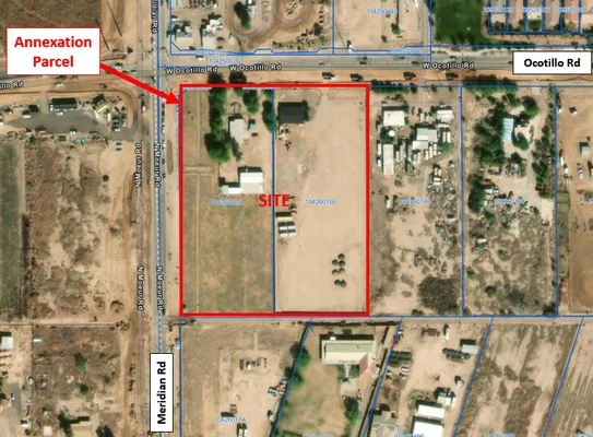
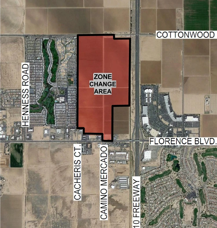
CASA GRANDE, AZ — Casa Grande’s Planning and Zoning Commission voted 4–3 on March 5, 2026, to deny a proposed zone change for approximately 273 acres of undeveloped land at the northwest corner of Florence Boulevard and Interstate 10.
What Was Proposed
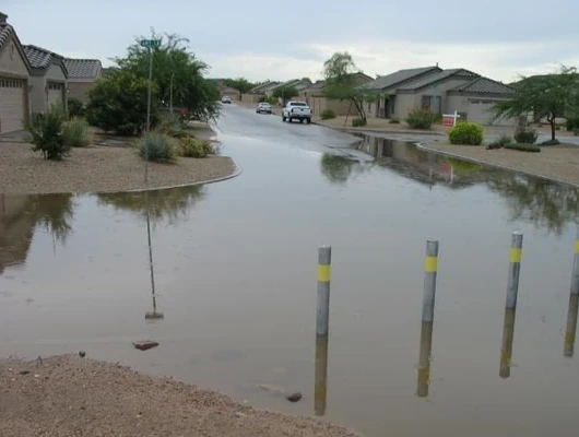
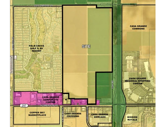
The site sits west of I-10, between Cottonwood Lane on the north and Florence Boulevard on the south, with Palm Creek RV Resort on the west.
The request would have changed the zoning from Urban Ranch (UR) to a Planned Area Development (PAD), a zoning designation that allows a mix of uses and customized development standards tailored to a specific site, rather than the uniform rules of a single standard zone district. The proposed PAD would allow a mix of commercial, residential, and light industrial uses, potentially including a grocery store. The applicant confirmed an active Letter of Intent from WinCo Foods, though no tenants have been formally approved.
The request was filed on behalf of Arizona Land Consulting by Darryl Wilson of Colliers Engineering and attorney Wendy Riddell.
The land currently carries an Urban Ranch zoning designation, which Senior Planner James Gagliardi described as a “holding zone” — an agricultural designation assigned at annexation that allows only low-density single-family development until a more intensive proposal is brought forward. The property was annexed into Casa Grande in 1989 and has remained undeveloped agricultural land since.
Because the commission denied the zone change, it cannot go to City Council unless the applicant submits a written request to the Planning Director within 30 days of the decision.
What the General Plan Says
The city’s 2030 General Plan designates most of this land for urban development. Two categories apply to this site.
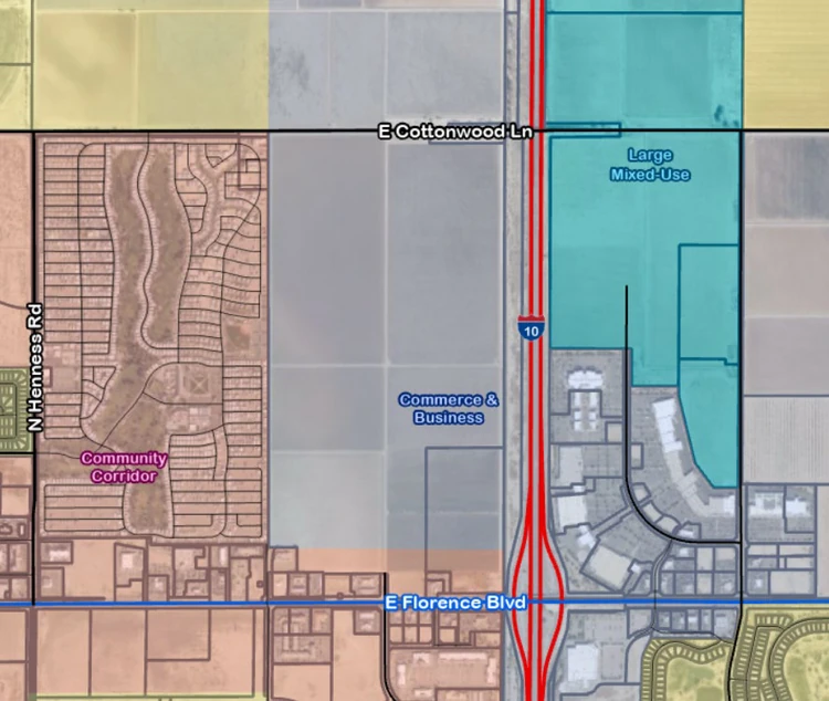
Commerce and Business (261 acres): The majority of the site falls under this category. It supports light industrial uses, commercial businesses, offices, and residential at densities above 10 dwelling units per acre. The general plan encourages blended commercial and industrial development here to prepare for shifts in retail demand and to promote a more resilient local economy. The emphasis is on campus-style and business park development with connections to arterial roads.
Community Corridor (12 acres): The southern strip of the property, closest to Florence Boulevard, falls under this category. The designation promotes a strong pedestrian environment, with buildings brought close to the road and parking de-emphasized. It supports retail, offices, restaurants, and medium-to-high density residential — up to 25 dwelling units per acre.
History of the Property
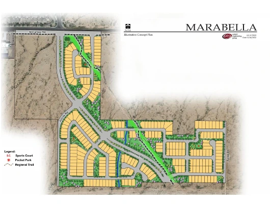
In April 2023, the Planning Commission heard a zone change request for the same 273 acres — then called the “Casa Blanca” PAD — and voted 4–0 to recommend approval to City Council. That proposal designated specific areas within the plan for each type of use. The current proposal does not. Instead, any of the three use types — commercial, residential, or light industrial — could occur anywhere on the parcel, subject to setback and buffer requirements that vary by location. The Casa Blanca PAD was scheduled for City Council but was repeatedly postponed at the applicant’s request and ultimately withdrawn.
What Could Be Built — and Where
No specific buildings or tenants have been formally approved. The zoning establishes a framework that limits what uses are permitted. According to the zoning document and staff presentation, permitted uses include residential at medium to high density (not single-family), commercial uses such as retail, restaurants, and offices, medical offices, business park and office campus development, and light industrial uses.
The planned extension of Camino Mercado — a north-south collector road through the site — creates two general development areas.
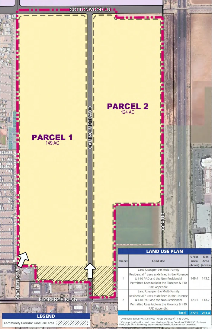
Parcel 1 (west of Camino Mercado) sits closer to Palm Creek Resort and is subject to the strictest setback and buffer requirements. The applicant described this area transitioning from lower-intensity uses nearest Palm Creek toward more commercial uses closer to the road interior.
Parcel 2 (east of Camino Mercado, toward I-10): The zoning anticipates more intense commercial and industrial development in this area given its direct freeway frontage.
The southern edge of the property falls within the Community Corridor designation, which the general plan directs toward street-facing retail and higher-density residential.
The applicant described a proposed layout with commercial uses closest to Florence Boulevard, transitioning to a mix of multi-family residential and business park development in the middle, and light industrial uses toward the rear of the site near I-10.
Commissioner Aldrete said: “When you drive through Casa Grande, you’re driving pretty much next to farmland for almost all of it. If we rezone this property, it provides that opportunity for users to come in and develop next to the freeway and provide that sign that things are happening in Casa Grande.”
Proximity to Palm Creek Resort
Palm Creek Resort, which sits directly on the western border of the site, is a medium-density RV and manufactured home community. Palm Creek resident Bobbi Seabolt stated the resort has approximately 2,375 sites and up to 4,000 residents during peak season.
The zoning included the following proposed protections along the Palm Creek boundary:
- A 50-foot buffer setback from all Palm Creek-adjacent boundaries for any use
- Within that setback, two rows of landscaping are required, including drought-tolerant canopy trees and a second row of hedges or shrubs
- Residential buildings adjacent to the Palm Creek boundary limited to 45 feet in height; residential more internal to the development could reach up to 60 feet
- Commercial development between 55 and 75 feet, with an additional 3-foot setback required for every foot above 55
- Light industrial height standards ranging from 65 to 80 feet
The proposal also committed to a minimum of 15% open space, approximately 42 acres.
Data Centers
Commissioner Aldrete raised a concern about data centers — specifically on Parcel 1 — raising concerns that cooling equipment from large data centers can produce low-frequency noise that travels long distances, and noting that many Palm Creek residents live in RVs rather than permanent structures.
Riddell responded: “I think it’s unlikely that this whole site develops as a data center — that’s not our primary objective here. Certainly it is a possible use. I think we’d be willing to suggest a noise study and noise limitations on the property line that couldn’t exceed 55 during the day and 50 at night.”
No formal stipulation was added to the zoning before the vote.
Roads and Traffic
The transportation master plan prepared by Lokahi Engineering estimates 15,961 net new weekday vehicle trips at full build-out, with approximately 978 during the AM peak hour and 1,375 during the PM peak hour. Commercial uses are projected to generate the highest share of those trips.
Florence Boulevard is a city project proceeding independently of this development. The transportation master plan recommends widening it to a full six-lane principal arterial. City Traffic Engineer Clark Clantanoff confirmed a progressive design/build team has been selected and is close to contracting for the first section, widening Florence from I-10 to Hennis Road. Design work is expected to begin within months, with construction possible roughly a year from now if fiscal year 2027 funding is approved. Clantanoff noted this is dependent on budget approval.
The following roads are contingent on development of the site. The developer would be responsible for constructing all internal roadways.
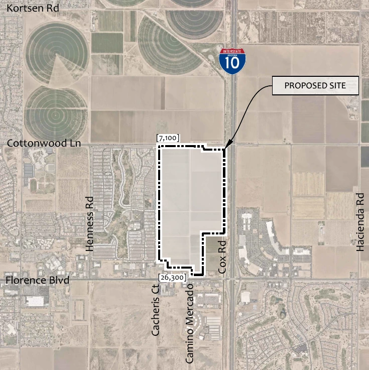
Cottonwood Lane: The transportation master plan recommended expansion to four lanes.
Camino Mercado: To be built as a collector road serving as the main north-south spine connecting Florence Boulevard to Cottonwood Lane. Traffic engineer Jamie Blakeman of Lokahi Engineering confirmed it is intended to be four lanes — two in each direction.
Cacheris Court: Gagliardi said it would be extended as a collector road tying into the development, either connecting south to Florence Boulevard or curving north to connect with Camino Mercado.
Palm Creek resident Bobbi Seabolt noted that major improvements to Florence Boulevard, Cottonwood Lane, and the I-10 interchange at Kortsen Road are not anticipated until approximately 2030 or 2031, and that funding depends in part on ADOT participation.
Commissioner Aldrete said: “A PAD of this size could take 20 plus years to develop. I think we have time to get a lot of those roadway improvements in by the time this sees significant development — especially if a lot of those are planned by 2030.”
Site Plans and Public Input Under State Law
Under Arizona House Bill 2447, municipalities were required to shift certain land development approvals from public hearings to administrative staff review. Casa Grande’s City Council had already moved site plan reviews to administrative staff, with plat approvals shifting to administrative review as of December 31, 2025. As a result, individual site plan reviews for developments like this are now processed administratively by city staff rather than through public hearings before the Planning Commission or City Council.
Planning and Development Director Dan Coxworth confirmed that once a PAD is approved, individual site plans go through an administrative review process rather than a public hearing.
Coxworth told the commission: “At a minimum, we would notify a site plan review to property owners within 300 feet, but there is discretion to expand that notification wider as determined by the planning department.” Gagliardi confirmed there would be no newspaper publication. Coxworth added that sign postings are not required, but that “there could be a requirement for a neighborhood meeting.”
Chairman Benedict said: “This is too big to have no input. The public, in general, has become very limited in the kind of input it can get into these kinds of developments. This is so large to just give a carte blanche.”
Vice Chair Garza, who also serves as Deputy Director of Public Works for Pinal County, said: “I don’t have the full faith in the staff — if you’re bringing things to us that are not up to par, I don’t have faith that the process of the site planning is going to do all that due diligence for the public.”
Commissioner Aldrete responded: “We can’t really require them to do anything against state law. The only other way I could see us providing an avenue to get more public input on all of the uses they’ve proposed is making every single one of the uses a conditional use, which is a ridiculous suggestion.”
Commissioner Clegg said: “It’s the gateway to Casa Grande. It’s a big economic development push. I understand what you’re saying, and unfortunately the state has deemed that rule necessary, but we need to move on with progress.”
Public Comment
Four Palm Creek residents spoke during the public comment portion of the hearing.
Bobbi Seabolt, a 20-year Palm Creek resident, urged the commission not to approve the rezoning. She described the proposal as too vague and premature, raised concerns about road readiness, and noted the transportation master plan does not anticipate major improvements until 2030 or 2031. She noted that approximately 4,000 people live in Palm Creek and said she believed all of them would oppose the rezoning. She argued the notification process had left most of them unaware of the hearing, stating that individual Palm Creek residents had not been notified because notices were sent to the park’s out-of-state management company rather than to residents directly.
Seabolt also made a broader argument about the site’s significance to Casa Grande’s identity. Visible to millions of drivers on I-10, she said the corner represents an opportunity to define what the city stands for. She pointed to the upscale Promenade and Mission Royale residential development on nearby I-10 corners, along with a prosperous auto dealership, as examples of the kind of development that reflects well on the city. She argued Casa Grande’s future is as a bedroom community for Phoenix and Tucson, and that allowing warehouse distribution centers or truck bays on that corner — all permitted under light industrial — would undermine that vision.
Seabolt also raised water, noting that Governor Hobbs had signed legislation allowing treated wastewater effluent to be used for new home construction, and that Senate Bill 1611 now permits agricultural water to be converted to residential use. She argued these tools were unavailable when the General Plan was written and give the city new options for the site.
Deborah Farrell focused primarily on the character and open space of the community, noting that Palm Creek residents contribute to local retail spending during peak season and warning that industrial development could deter seasonal visitors from returning.
John Farrell offered brief remarks about the view from Palm Creek, noting that residents had chosen the location for its open eastern horizon and that tall structures would eliminate the sunrise views that drew them there.
Gloria Mason raised traffic concerns on Cottonwood Lane and Hennis Road, where she said accidents occur regularly due to the lack of traffic signals. She echoed Seabolt’s point that individual residents do not receive direct notification of land use hearings because notices go to the park’s out-of-state owner rather than to residents.
In response, the applicant’s attorney stated they had attempted door-to-door outreach inside Palm Creek, but the management company denied access because it is a gated community.
How the Commission Voted
For — Ibrahim, Clegg, Aldrete (3 votes):
Commissioner Aldrete, who made the motion to approve, said the development standards in the proposal are comparable to city code requirements and that the property’s location next to I-10 makes it appropriate for the proposed uses. He stated the 20-plus-year build-out timeline would allow road improvements to keep pace with development.
Against — Smith, Hubbard, Garza, Benedict (4 votes):
Chairman Benedict said the scale of the approval — nearly 300 acres to be processed administratively going forward — was too large without further public input. Vice Chair Garza cited concerns about the readiness of the application and the loss of public process under state law. Commissioner Hubbard cited traffic as her primary concern. Commissioner Smith voted no.
Applicant’s Path to City Council
Under city code, a zone change to PAD denied by the Planning Commission may still be reviewed by the City Council, but only if the applicant submits a written request to the Planning Director within 30 days of the commission’s March 5, 2026 decision.