Key Points
- A 353-acre project on Casa Grande’s east side moved one step closer to approval.
- The plan sets a vision for future mixed commercial, housing, and business uses.
- It does not approve construction or change zoning yet.
- City Council makes the final call on Dec. 15, 2025.
- Leaders want coordinated growth, not scattered development.
- Residents voiced worries about traffic, industry, and dense housing.
- Officials say more public input and reviews will happen before anything is built.
- The area could someday include shops, offices, restaurants, homes, and services.
- Infrastructure and utilities will need major upgrades.
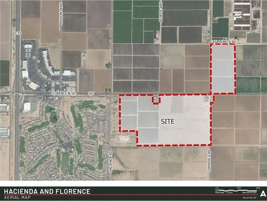
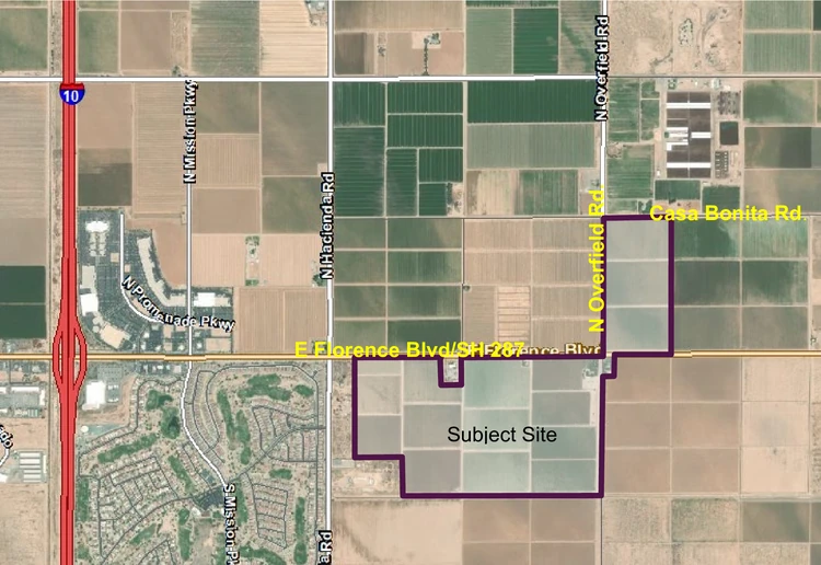
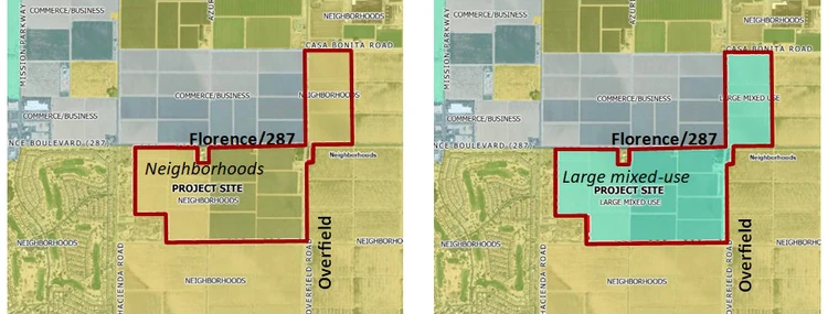
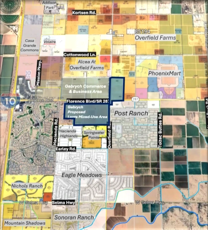
Casa Grande’s Planning and Zoning Commission voted unanimously Thursday, November 6, 2025, to advance a major general plan amendment for 353 acres near Florence Boulevard and Overfield Road. The commission recommended approval for changing the land designation from Neighborhoods to Large Mixed-Use, moving the proposal forward to City Council for a final decision on December 15, 2025.
Commission Votes 7-0 to Recommend Approval
The Planning Commission approved the request by Alex Fish of ABLA on behalf of Gabrych Family LP after hearing presentations from city staff and the applicant. This was the second of two required public hearings for major general plan amendments. The first hearing occurred October 16, 2025, with no vote taken. All seven commissioners voted in favor of forwarding a positive recommendation to City Council. The property sits at a strategic location along State Route 287, near the Interstate 10 interchange.
Chairman Brett Benedict acknowledged concerns about industrial uses but emphasized the benefits of professional services, restaurants, and entertainment facilities for the growing area. The commission stressed the importance of remaining vigilant as development proposals move forward.
Strategic Location East of Interstate 10
The 353-acre site is located at the intersection of Florence Boulevard, also known as State Route 287, and Overfield Road. The property sits east of Interstate 10, near the Casa Grande Promenade shopping center.
The area is positioned between existing commercial development to the north and west and residential neighborhoods to the south and east. Most of the surrounding land remains farmland, though multiple planned area developments have been approved throughout the eastern side of Interstate 10.
Understanding General Plan Amendments vs. Zone Changes
Senior Planner Jim Gagliardi explained the distinction between a general plan amendment and a zone change.
“The general plan does not change the property zoning,” Gagliardi said. “What the general plan does is it’s a high level document that is more of a vision document that prescribes what are appropriate future zone districts for a particular area.”
The property would remain zoned Urban Ranch and General Business until the owner applies for a zone change. Any future zone change would require additional public hearings before the Planning Commission and City Council. This gives the community multiple opportunities to weigh in on specific development proposals.
Current Land Use vs. Future Possibilities
Current Zoning (Remains Unchanged)
- 349.8 acres zoned Urban Ranch: single-family at low densities, agricultural uses
- 3.2 acres zoned General Business: retail, restaurants, offices, hotels, personal services
Future Development Possibilities
Under Current Neighborhoods Designation:
- Could support up to 100 acres of multifamily development
- Would require multiple separate zone change requests with size limits (sites up to 20-25 acres each)
- Density: 12 units/acre (sites up to 25 acres) or 24 units/acre (sites up to 20 acres)
Under Proposed Large Mixed-Use Designation:
- Could support up to 176.5 acres for residential uses
- Medium/high-density multifamily limited to 88.25 acres
- Requires single Planned Area Development (PAD) for entire site, allowing coordinated planning rather than fragmented rezonings
- Supports diverse uses: residential, commercial, industrial, medical campuses, offices, professional services, restaurants, entertainment, hospitality, educational facilities, religious institutions
Key Difference: Large Mixed-Use limits medium/high-density multifamily to 88.25 acres compared to 100 acres under the current Neighborhoods designation.
Land Transition Strategy for Compatible Development
Gagliardi presented a conceptual layout showing how mixed-use development could transition between different intensities. The strategy would place industrial or commercial uses nearest to Florence Boulevard, where the heaviest traffic is expected. Residential uses would sit in the middle, with standards becoming more restrictive toward the edges where lower-density neighborhoods exist.
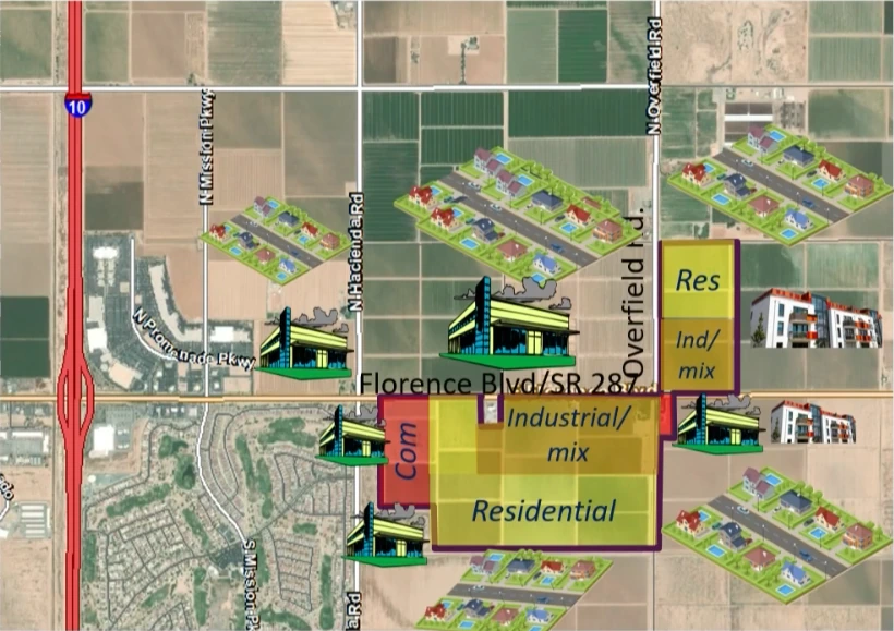
“They would probably arrange their uses something like this, where they propose industrial or a mixture of industrial and commercial nearest Florence Boulevard since that is a state highway,” Gagliardi explained. “But then between that and the less intense uses would be residential.”
The Large Mixed-Use category includes specific balance requirements. No more than 70 percent of the area can be commercial. No more than 50 percent can be industrial. No more than 50 percent can be residential. These standards ensure a mix of uses rather than a single-purpose development.
Infrastructure Plans Include Future Interchanges and Road Improvements
The long-range transportation plan shows future Interstate 10 interchanges at both Kortsen Road and Selma Highway. These interchanges would provide additional access to the property from the north and south. Principal arterial roads are planned leading north and south from the site, though none are currently improved.
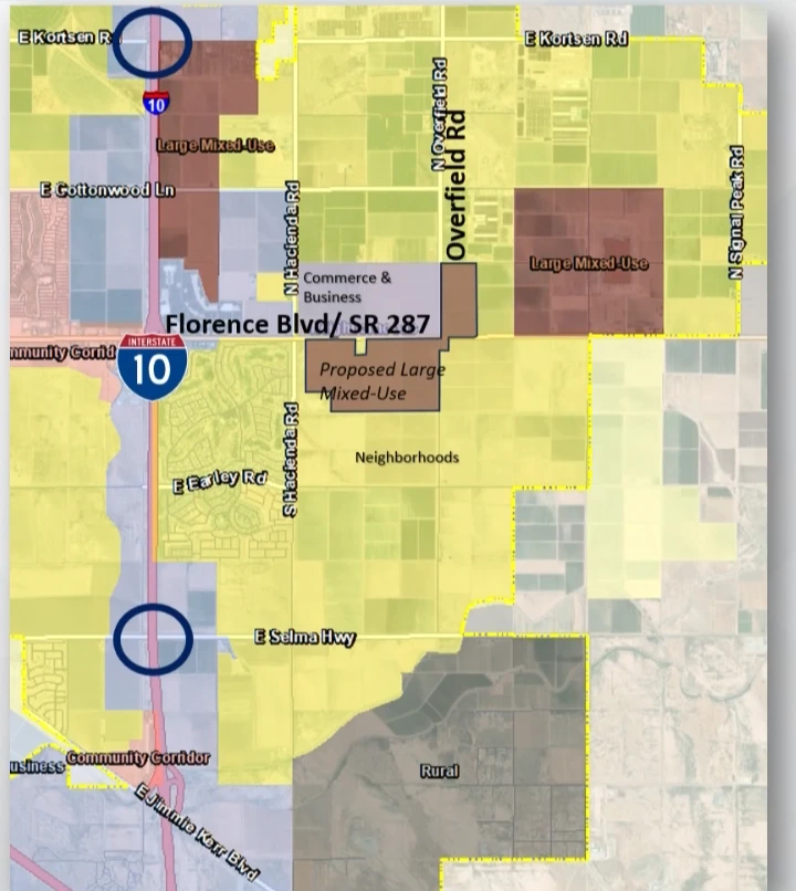
“In our long-range plan, there are future interchanges with both Kortsen and I-10 and Selma and I-10,” Gagliardi said. “And also there’s principal arterial roads leading from this site, north and south.”
Infrastructure improvements would occur in phases as development moves forward. At the site plan stage, developers must demonstrate adequate utilities and roadway access. The Regional Trail Plan shows the Hacienda-Overfield community trail running parallel to Overfield Road, which would require appropriate right-of-way dedication or easements during later entitlement stages.
Sewer Capacity Concerns and Satellite Treatment Options
Vice Chairman Celeste Garza raised questions about sewer service availability for development east of Interstate 10. Gagliardi confirmed that much of the east side currently lacks direct sewer access to the city’s wastewater treatment facility.
The current wastewater master plan calls for a new line running north on Hacienda to Kortsen, then west under Interstate 10 to connect with the recently upgraded Kortsen line. However, the approval of Post Ranch’s preliminary plat has introduced new possibilities.
“They’re actually proposing a satellite waste water treatment facility on their site,” Gagliardi explained. “It’s possible that’s going to end up evolving to something that can accommodate more waste water discharge than just Post Ranch itself.”
While not large enough to handle all development shown on future plans, the satellite facility could serve multiple properties. Each development proposal involving wastewater discharge will require evaluation to determine the best route for sewage.
Timeline Expectations for Future Development
Alex Fish, representing the applicant, noted that the Neighborhoods designation is applied to large areas of the city where no specific development plan exists. Most areas east of Interstate 10 carry this designation. Developers typically amend the land use when they have specific plans.
“Most of the areas that get developed eventually come in and they will amend the land use to be a more appropriate use for what they intend to develop,” Fish said.
Gagliardi noted that development in the area may take years to come to fruition and is dependent on water supply. The property lacks Certificates of Assured Water Supply, which prevents easy development of traditional single-family neighborhoods. Certificates are required when creating more than five parcels.
According to the applicant’s report, certain development types—such as multifamily residential, commercial, office, and other non-residential uses—may be permitted without certificates under current Arizona Department of Water Resources regulations. The applicant noted that the city is currently actively working to find solutions to allow single-family development in the future.
Residents Voice Concerns About Industrial Uses and High-Density Housing
Katie Halverson expressed support for commercial and business development but objected to the industrial component. She noted existing traffic problems on the west side of Interstate 10 related to industrial uses and warned against creating similar issues on Florence Boulevard.
“You yourself said we already have traffic problems on the west side with the industrial, with trucks,” Halverson told the commission. “And now we’re gonna take and put potential industrial into this area and take truck traffic through what is becoming a commercial area for Casa Grande. We have the shopping mall there, we already have issues. We have a lot more homes coming out here.”
Halverson also questioned whether the development would enhance downtown Casa Grande, as mentioned in both staff and applicant narratives. She suggested half of east-side residents rarely visit downtown except for church or breakfast at the Big House Cafe.
Eleanor Forster of Mission Royale Adult Village read a letter expressing concern about high-density housing outside the city’s downtown core. She feared losing Casa Grande’s rural and agricultural heritage to overgrowth.
“I don’t feel that high density housing, especially, is appropriate on the outer edge of the city limits,” Forster said. “My main concern is the inclusion of high density housing to this plan change, which is outside the city downtown core.”
Staff Recommends Approval Based on Strategic Location
Gagliardi presented staff’s recommendation for approval, emphasizing the property’s adjacency to a state highway with an Interstate 10 interchange. He noted that two other areas on the east side of Interstate 10 already carry the Large Mixed-Use designation: the area north of the Promenade and Phoenix Mart.
“This area being proposed large mixed use would not be an orphan on this side of the interstate,” Gagliardi said. “There are two other areas already designated as large mixed use.”
Gagliardi explained that the determination criteria for general plan amendments focus on how the area could be sufficiently supplied with utilities and access in the future. He noted the staff report addresses these criteria in detail. The recommendation centers on the property’s location adjacent to State Route 287 with an Interstate 10 interchange.
Staff noted one email received opposing the change due to potential multifamily development. However, the current Neighborhoods designation already allows multifamily development. The Large Mixed-Use designation would actually limit multifamily acreage to 88.25 acres for medium and high density, compared to potentially 100 acres under Neighborhoods.
The staff recommendation highlighted that future Planned Area Development proposals would face public hearings before both the Planning Commission and City Council. Any subsequent amendments to the PAD would also trigger public hearings where the commission and council could evaluate whether proposed changes are appropriate. The Large Mixed-Use category supports multifamily but does not require it.
Commissioner Addresses Public Concerns About Future Entitlements
Commissioner Garrett Aldrete responded to public concerns, acknowledging that industrial uses and high-density housing raise valid concerns.
“As the applicant said, the neighborhoods category kind of exist as a placeholder until something comes through that actually has a plan to develop into something else and that’s when they usually make that change,” Aldrete said.
He explained that future Planned Area Development proposals would require developers to show compatibility with surrounding uses.
“I think once they come back with a PAD, they are going to have to show that they’re incorporating those things in a compatible way, if they are,” Aldrete said. “And that could be restricting density near existing low density residential.”
Aldrete emphasized that the Large Mixed-Use standards include built-in limits on industrial and residential percentages. He encouraged residents to participate in future public hearings when specific Planned Area Development proposals come forward.
“I think when that point comes, it’d be very important for not just us as a commission, but staff as well, to kind of remember some of those concerns,” Aldrete said.
Chairman Supports Plan, Stresses Need for Diligence
Benedict said the word “industrial” in the designation made him nervous but noted other uses would benefit the area. He mentioned professional services, restaurants, and entertainment facilities as positive additions for the growing corridor.
“Some of the professional services and restaurants and entertainment facilities and all of those things, I think will be beneficial to the area in time as it grows,” Benedict said.
He stressed the importance of remaining diligent as development proposals move through the approval process. The commission must carefully review each future zoning request and site plan to ensure compatibility with surrounding areas.
Garza asked whether future Planned Area Development proposals would come back to the commission. Benedict confirmed they would.
Next Steps: City Council to Make Final Decision December 15
The City Council will hold a public hearing on the general plan amendment at its December 15, 2025 meeting at 7:00 p.m. in City Council Chambers. The council represents the final authority on major general plan amendments.
If approved by council, the property owners can then pursue a zone change to Planned Area Development. That separate process would require additional public hearings before the Planning Commission and City Council. Any future amendments to the PAD would also require public hearings. Site-specific development plans would face further review at the site plan stage, ensuring adequate infrastructure before any construction begins.